Rapid carbon accumulation at a saltmarshrestored by managed realignment exceeded carbon emitted in direct site construction

In the last few years, I have expanded my research into the burial of carbon in saltmarsh environments, especially around the UK. This is the first paper I have published on the topic. The paper is available Open Access via the journal website.

A composite map/aerial image of the Steart Marshes saltmarsh site

Saltmarshes, which is an coastal wetland which is flooded and drained by saltwater brought in on the high tide, are natural features acrosst the UK and around the world. In the UK, many saltmarshes were drained to form farmland, with a sea defence built between the drained marsh and the river or estuary. Rising sea levels threaten the reclaimed marshes, and the nearby fields, towns and villages, with flooding. Often it is decided that retreating from the drained land is the best way to protect other, more valuable, assets nearby. Through a process called “managed realignment”, the sea defences are breached and the tide returns to the saltmarsh.

Realigned saltmarshes are often lower than the local high tide level, and are rapidly filled with sediment and saltmarsh plants when the water returns. This creates a habitat that can attract wetland birds and, since the sediment has organic carbon associated with it, also generates and opportunity to bury carbon in the marsh.

This paper investigates two things: how much organic carbon was buried on a realigned saltmarsh in the first years after it was created, and how does this carbon burial compare to the emissions generated by the construction of the site.

Samples were collected from Steart Marshes, a site in Somerset, UK, that was flooded in 2014. The samples were analysed for their total carbon and organic carbon content using analytical facilities here at Manchester Met. The carbon concentrations were scaled up to the entire site using sedimentation data calculated from laser scans of the marsh collected at different time points.
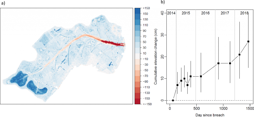
There has been a very rapid build-up of sediment at Steart Marshes since the sea defences were breached

We found that the organic carbon burial rate (19 tonnes per hectare per year) was very high compared to other saltmarsh sites, mostly because the sediment built up very rapidly (75 mm per year) after the sea defences were breached. The organic carbon buried on site is much greater than the carbon emissions generated by the diggers and bulldozers used to make the new marsh, and so it seems that there has been a net climate benefit by creating the marsh.

However, the next piece of the puzzle is to fully understand the types of organic carbon being buried on the site. Not all carbon has the same climate benefit associated with it, and so further work is required to properly calculate the climate change mitigation potential of restoring saltmarshes.
Characterization of diverse bacteriohopanepolyols in a permanently stratified, hyper-euxinic lake

This paper is available Open Access via the journal website.

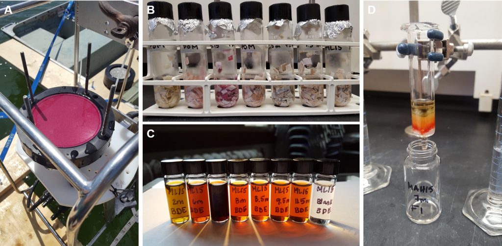
Water filters, extracts and column chromatography for the samples from Mahoney Lake

This publication, led by Molly O’Beirne from the University of Pittsburgh is a really exciting look at BHP biomarkers and microbes in an unusual Canadian lake. My role was to measure and identify the BHPs present in the lake, including finding a ‘new’ BHP that had not been described before.

Mahoney Lake, British Columbia, is a small lake with a really high concentration of sulfur, and a low concentration of oxygen. This classifies it as ‘euxinic‘, and Mahoney Lake is 100 times more sulfidic than the Black Sea. Not only that, but the lake switches from oxic to euxinic within the top 7-8 metres, meaning that sunlight can penetrate into the euxinic layer. This study looked at the changing bacterial communities and BHP biomarkers present in the different layers of the lake.

Water filter samples were collected at a series of depths in the lake, from the oxic layer, through the changeover to euxinia (the ‘chemocline’), down to the sediment at the bottom. At the chemocline, a large community of purple sulfur bacteria were collected which made the filters turn a bright pink-purple colour (see the picture above), which makes a nice change from the usual brown-grey water filters usually collected from lakes and rivers.

Chromatogram and mass spectrum showing the novel BHP with m/z 710

Back in the lab in Pittsburgh, these filters were extracted using solvents and the BHP molecules were separated out from everything else, transferred into small vials, and posted across the Atlantic. After a few days in customs, they made it to Manchester Metropoltian to be analysed on the LC-MS. When looking through the data, there were several common BHPs present, but also a large amount of a previously unknown BHP molecule. It was seen on the chromatogram at a similar time to the ubiquitous ‘aminotriol’ BHP, but careful analysis of the mass spectrum showed that the molecule and its fragments were four mass units ligher than aminotriol, with m/z (mass to charge ratio) 710 rather than 714. We think that this molecule has the same structure as aminotriol, but has two carbon-carbon double bonds in the structure.

Since this molecule was only found in the lower parts of the lake, we think it could be directly linked to euxinic environments. In future work, I will look for this molecule in other euxinic and oxic lake samples to test whether it is a reliable biomarker for euxnia. If it is, BHP 710 can be used to identify euxinia in ancient lakes throughout the geological record.

To find out which bacteria might be making these molecules, Trinity Hamilton from the University of Minnesota sequenced the bacterial genomes present in the lake filters. Genes that produce BHPs were found in samples from the lower parts of the lake, and the BHP producing bacteria are probably Deltaproteobacteria, Chloroflexi, Planctomycetia, and Verrucomicrobia.

At the bottom of the lake, the BHPs present change again. Bacteriohopanetetrol (BHT) is the most common, and methylated BHTs are only found in the lake sediments. This makes us think that bacteria living in the oxygen-free sediments at the bottom of the lake are the source of the methylated BHTs, rather than bacteria living in the oxygenated upper layer of the lake.

Overall, this has been a really fun and interesting study to be part of, and provides loads of new research questions as well as answers. Other researchers looking to analyse BHPs in their samples are welcome to get in touch to discuss collaborations.

The quantification of di-octyl terephthalate and calcium carbonate in polyvinyl chloride using Fourier transform-infrared and Raman spectroscopy

This article is available Open Access via the journal.

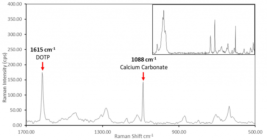
Typical results when measuring PVC using Raman spectroscopy

A slight detour from my usual environmental chemistry work, this paper was led by PhD student Kate Irvin and looks at characterising PVC samples in an industrial setting, finding ways to optimise the product development process.

When developing a new polymer product, it is important to regularly test its properties and confirm its ingredients. Typical tests take hundreds of hours and can delay the development cycle, adding costs to the process. In this paper we demonstrate some rapid, non-destructive techniques for quantifying the amount of plasticiser (dioctyl terephthalate) and filler (calcium carbonate) within a PVC sample.

Fourier transform-infrared spectroscopy and Raman spectroscopy were used, since they are quick, easy-to-use and non-destructive methods of identifying samples. The time savings alone of using these methods compared to using traditional hardness, softness and tensile tests could reduce product development costs by 50%.

Methanotroph-derived bacteriohopanepolyol signatures in sediments covering Miocene brown coal deposits

This paper is available Open Acess via the journal website.

When I joined Manchester Metropolitan University in 2016, I was awarded a small grant to set up an analysis facility measuring a group of molecular biomarkers, bacteriohopanepolyols (BHPs), that are found in environments throughout the world. This paper is the first to be published on BHPs measured at Manchester Met.

Cores of polish lignite used in this study

In this paper, led by Anna Pytlak, samples from two Polish lignite deposits were analysed via LC-MS to see which BHPs were present in the samples, and whether these could be linked to methane-generating bacterial living in the rocks now, or millions of years ago.

My role, along with PhD student Saule Akhmetkaliyeva, was to extract the BHP biomarkers from the sediment samples and analyse them on the time-of-flight mass spectrometer at Manchester Met. The molecules found in the mass spectrometer were compared against known BHP results, and identified as being from various types of bacteria. This included both Type I and Type II methanotrophs (bacteria that consume methane), including some living methanotrophs.

BHP concentrations were higher in the lignite than the surrounding mineral soil, suggesting some form of active bacterial commuity supported by the lignite deposits that cannot be sustained in regular soil. Living methanotrophs means that there’s a chance some of the methane released over time by the lignite is eaten by the bacteria and not released to the atmosphere.

If you would like to measure BHPs in your own samples, please get in touch to discuss collaborations!

Spatio-temporal analysis of the potential toxicological burden of pollutants in a fluvial system, the River Irwell, Manchester, through anthropogenic activities (present and historical) and natural mechanisms

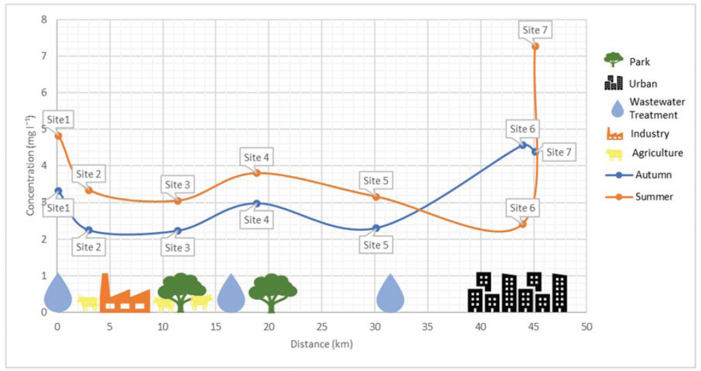
Changes in biological oxygen demand (BOD) along the River Irwell, Greater Manchester

This paper is available through the journal website.

A common topic of student research projects is monitoring and assessing the health of rivers around Greater Manchester. This paper represents a particularly good project by Haseeb Mahmood, who was motivated enough to carry his project through to publication.

In this work, Haseeb collected water samples along the length of the River Irwell, which flows from the Pennine Moors to the Manchester Ship Canal. Along its length it passes through industrial, rural, suburban, parkland and urban environments. These all affect the river water quality. For example, there are measurable changes in biological oxygen demand and phosphate concentration as the river passes by sewage treatment works.

Reassuringly, Haseeb measured lower heavy metal concentrations in the river during summer and winter 2019-20 compared to historical measurements on the same river, indicating that clean-up activities in the last 30 years have been worthwhile.

Signatures of the post-hydration heating of highly aqueously altered CM carbonaceous chondrites and implications for interpreting asteroid sample returns

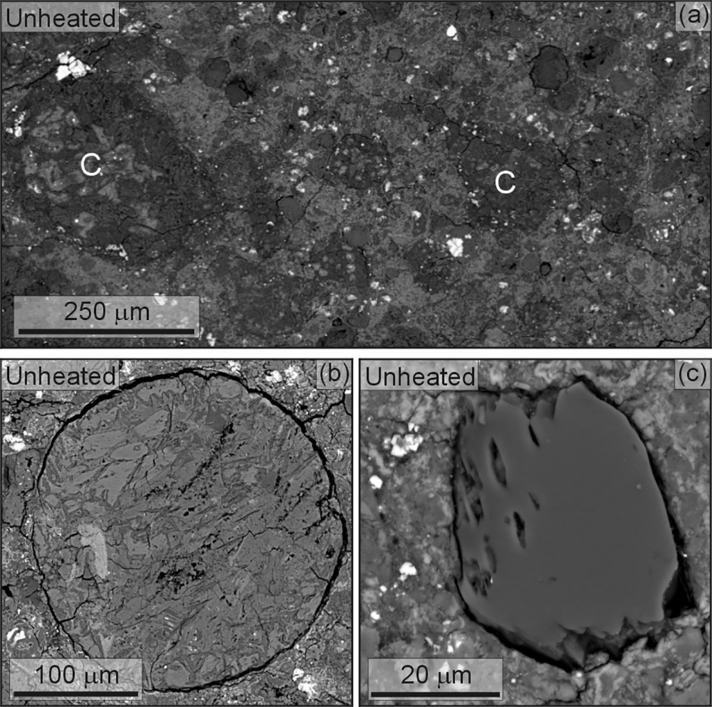
Backscatter electron microscope images of a meteorite

This paper is available as an Open Access article via the journal.

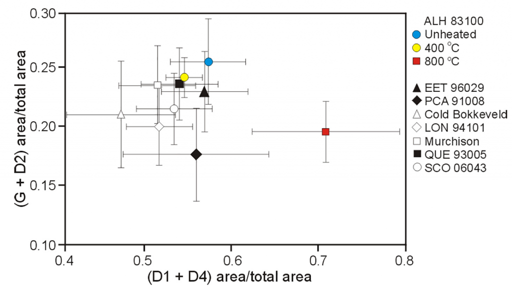
This research paper continues the work of Paula Lindgren, who I worked with earlier when looking at a suite of meteorites. In this paper, a single carbonaceous chondrite meteorite was heated in the laboratory to simulate the heating that took place during the life of a meteorite. A sample was studied using a series of different techniques, including scanning electron microscopy, Raman spectroscopy, infra-red spectroscopy, oxygen isotopic analysis and X-ray diffraction. It was then heated to 400 °C and 800 °C and studied again. We found that the minerals, isotopes and organic matter all changed with heating. Sometimes 400 °C was enough to make a change, sometimes no change was observed until 800 °C.

Changing Raman spectropscopy measurements from unheated (blue), 400 °C (yellow) and 800 °C (red) samples of the same meteorite

These changes can be used to work out the thermal history of meteorites collected on Earth, and even for asteroids sampled in space!

Carbonaceous material export from Siberian permafrost tracked across the Arctic Shelf using Raman spectroscopy

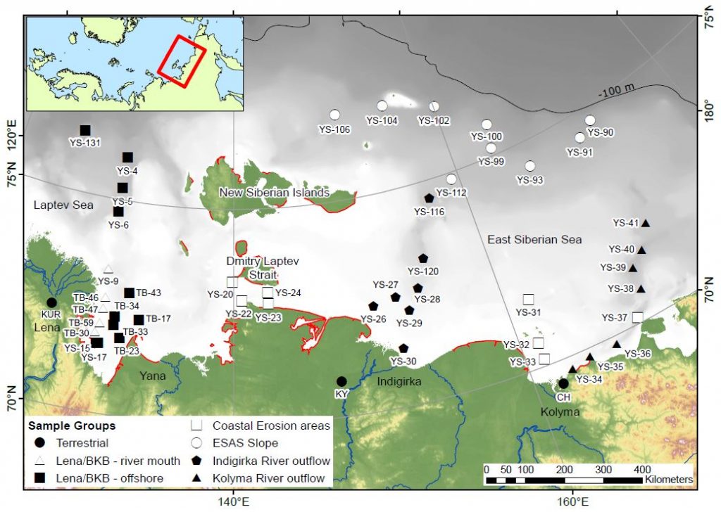
In this paper, published in The Cryosphere, we used Raman spectroscopy to trace carbonaceous material from the shoreline to the furthest reaches of the East Siberian Arctic Shelf.

Raman spectroscopy uses laser light to determine the molecular structure of a wide range of materials. During my PhD, I showed that Raman could be used to probe individual particles of organic carbon to show whether they were disordered, like coal, or crystalline sheets of graphite. This collection of carbon particles, known as carbonaceous materials, are particularly hardwearing and resistant to breaking down during erosion and transport. During my post-doctoral research, I then used a range of organic geochemistry techniques to investigate the transition from terrestrial to marine carbon across the East Siberian Arctic Shelf, showing that coastal erosion and river erosion were both supplying organic matter to the ocean.

Map of the samples used in this study. Red lines are areas of intense coastal erosion

This study uses the Raman technique on those same Arctic Shelf sediments to look at the sources and distribution of carbonaceous material on the shelf. The samples used in our paper were collected from close to the mouths of some major rivers, from areas experiencing rapid coastal erosion, and from hundreds of kilometres offshore.

Groups of spectra found in the shelf samples

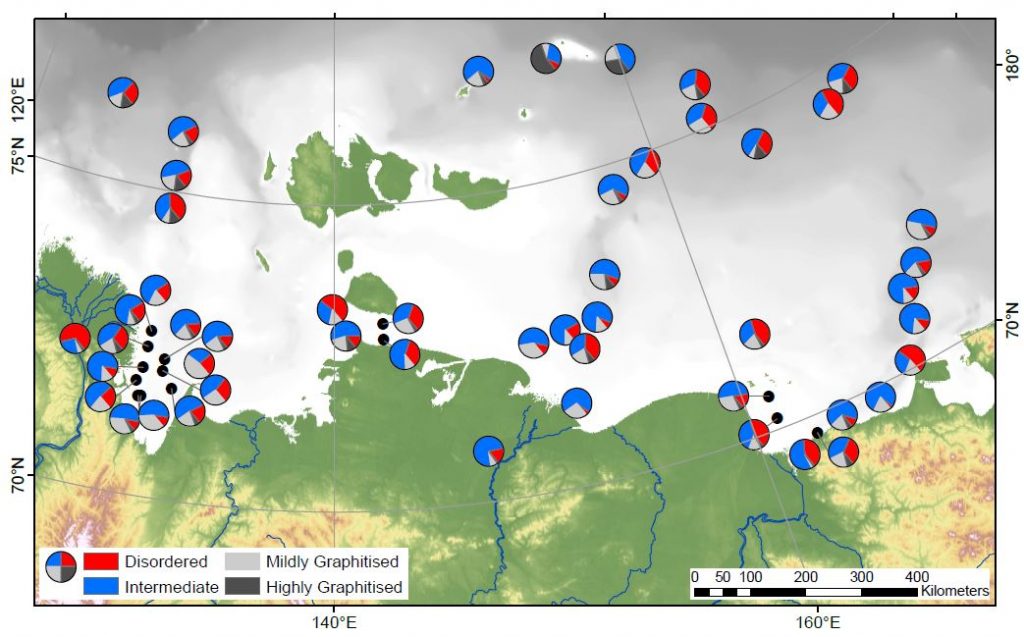
The hardest work, collecting over 1400 Raman spectra, was carried out by two undergraduate students, Melissa Maher and Jerome Blewett, who are co-authors on the paper. The collected spectra were then analysed using an automated peak fitting script, and grouped according to the shape of the fitted peaks. This provides an unbiased method for determining whether a carbon particle is highly graphitised, mildly graphitised, disordered, or somewhere in between. For each of the sites on the shelf we collected spectra from up to 30 particles, and looked at how many fitted into each group. Statistics were then used to spot patterns across the shelf.

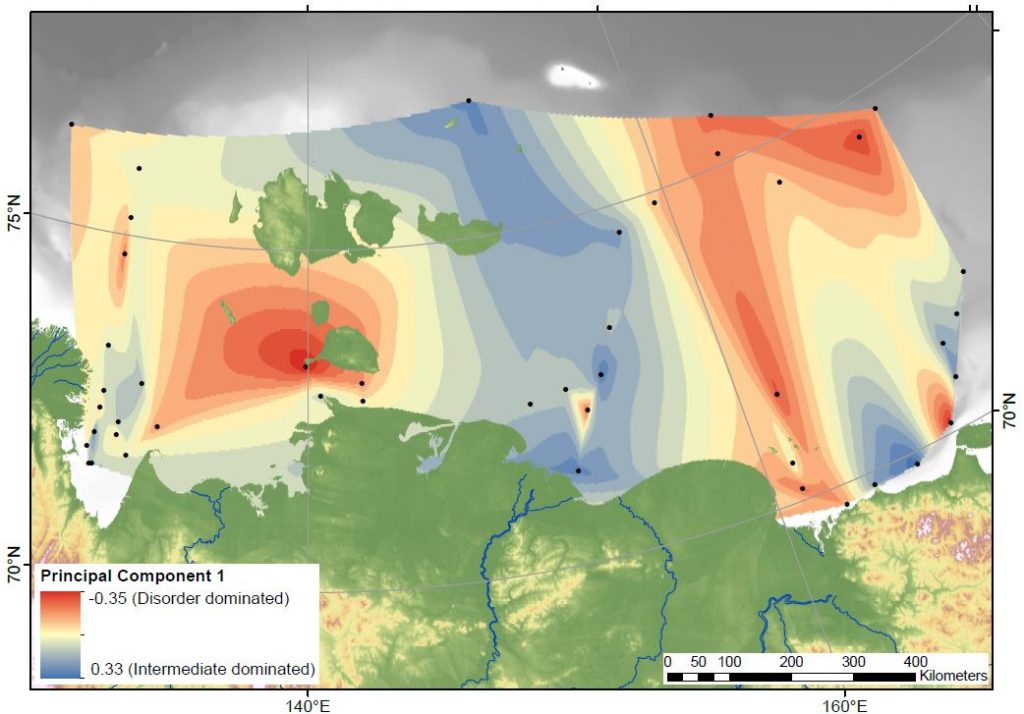
Distribution of "Disordered" and "Intermediate" carbon
Distribution of “Disordered” and “Intermediate” carbon

Our first finding is that the relative proportion of “disordered” and “intermediate” carbon particles varies, and that there are patches with more of one or the other group. At the coastline these patches align with two of the major rivers (Kolyma and Indigirka) and areas of rapid coastal erosion. Surprisingly, the patches can then be traced all the way across the shelf. We would have expected the currents in the ocean to have mixed the particles together further offshore, and in the biomarker studies we’ve done before we did not spot this kind of pattern. This means that Raman is a great way to trace the different sediment and carbon sources on the shelf.

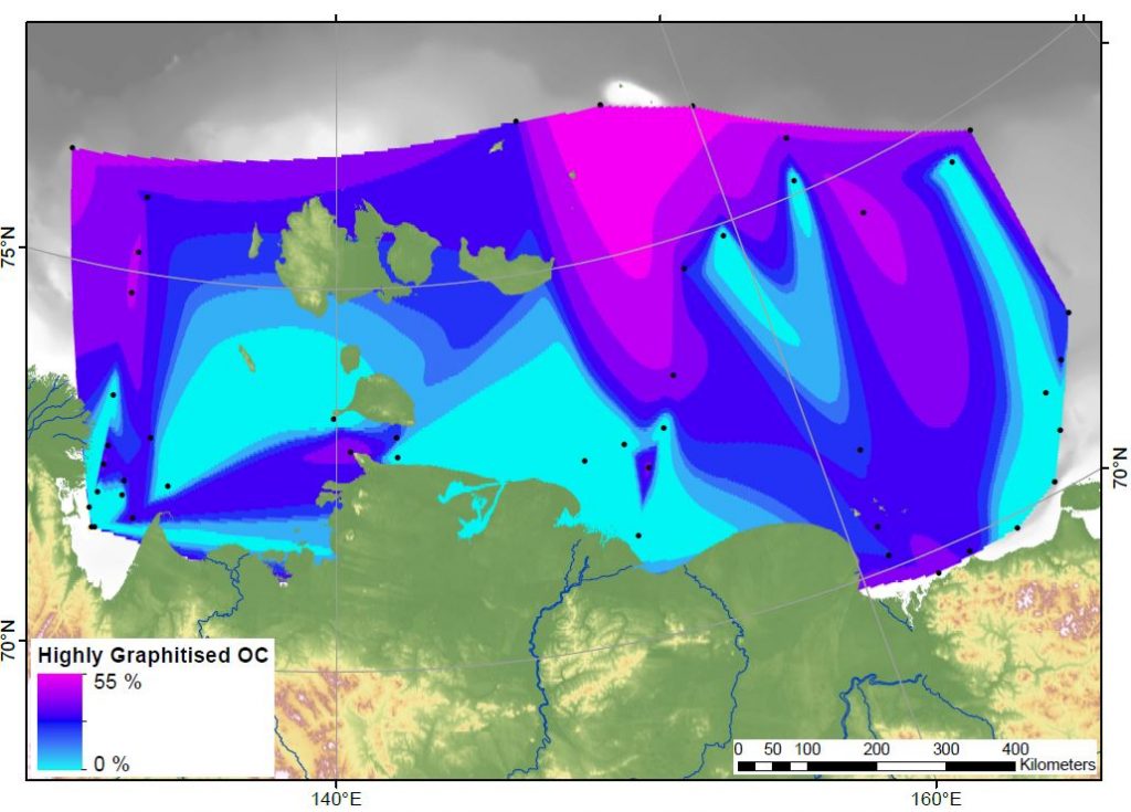
"Highly Graphitised" carbon is found in high proportions far offshore
“Highly Graphitised” carbon is found in high proportions far offshore

Our second finding is that the amount of “highly graphitised” carbon particles is highest in the furthest offshore samples. These very crystalline flakes of graphite are behaving differently to all the other carbon particle groups. It’s not clear exactly why this is, but one option is that everything else is breaking down and degrading before getting that far offshore. Or, the graphite particles could be so light that they sink very slowly, floating out to the shelf edge much easier than the other types.

This problem has implications for the global carbon cycle. These carbon particles have been released from permafrost on land and transported for hundreds of kilometres offshore, a trip that has taken thousands of years. If all of the carbonaceous material can survive the journey, it means that this fraction of the organic matter is not at risk of being degraded and released to the atmosphere as greenhouse gases. Burying it in the ocean provides protection from degradation for thousands or millions of years. Future studies should look at just how well the carbon particles can survive erosion and burial.

In summary, carbonaceous material is resilient to degradation and can be used to trace sediment sources across the Arctic shelf.

The Cryosphere, 12, 3293-3309, 2018
https://doi.org/10.5194/tc-12-3293-2018

Macromolecular organic matter across the East Siberian Arctic Shelf

Update: The paper is now published and can be downloaded from the journal webpage.

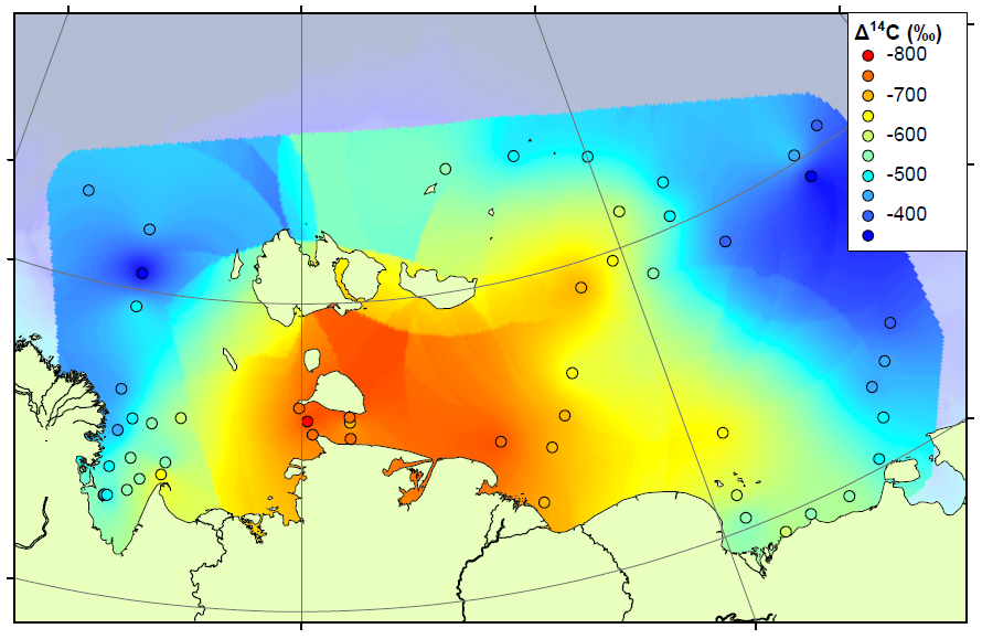
Map of radiocarbon ages across the ESAS

The study continues our work on the East Siberian Arctic Shelf, and contains two new datasets. The first is a radiocarbon study, measuring the age of organic matter on the shelf using carbon dating (see map above). By measuring the age, we can determine whether the carbon has come from the ocean (very young), the topsoil (quite young) or the coastal permafrost (thousands of years old). We combined our results with those already measured on the shelf to form the most complete radiocarbon map for this area. The high-resolution map shows that areas close to the shore and away from the major rivers are home to very old carbon, almost certainly sourced by erosion of old permafrost cliffs. Elsewhere on the shelf, the carbon is younger but not as young as modern topsoils or ocean carbon. Therefore the coastal erosion carbon is having an influence right across the shelf.

A pyrolysis probe can heat samples to 900 C in milliseconds

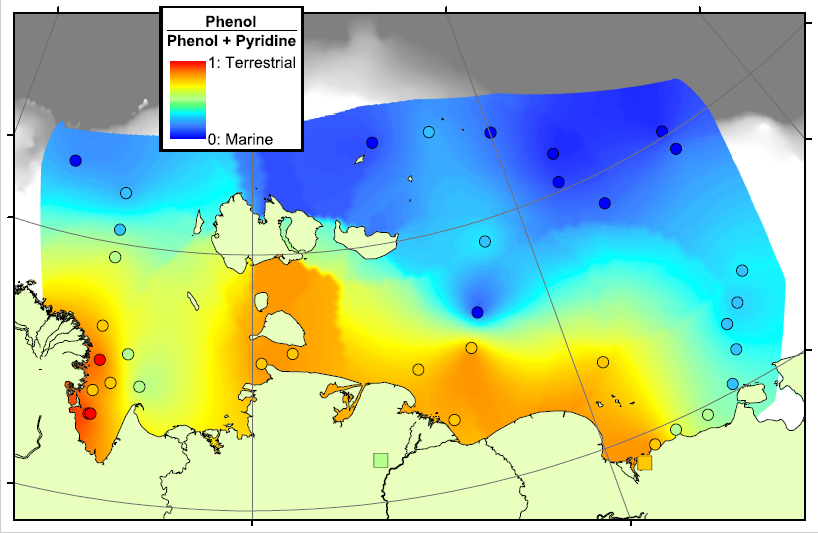
Our second technique is pyrolysis GCMS, where samples are smashed into small pieces using high temperatures and the small pieces are then analysed using GCMS. This technique generates a large amount of small pieces, too many to analyse each one individually, and so we decided to concentrate our efforts on a few target molecules. These included Phenols, which are probably sourced from lignin, a major component of land plants, and Pyridines, which are nitrogen-containing compounds probably sourced from proteins. We think that a lot of the Pyridines in the Arctic Ocean will come from organisms living in the ocean itself, and therefore the Pyridines are a potential tracer for marine organic matter. By comparing the concentrations of Phenols and Pyridines, we can estimate the amount of terrestrial and marine organic carbon in a sample.

Phenol-Pyridine ratio on the Arctic Shelf

In the map above, red areas are dominated by Phenols and are therefore rich in terrestrial carbon, blue areas are dominated by Pyridines and are therefore rich in marine carbon. This pattern matches very well with our previous work in the region, showing that there is a transition from terrestrial to marine conditions across the Arctic Shelf, and that the transition zone lasts for hundreds of kilometres offshore. This means that there is a lot of terrestrial carbon being deposited, and hopefully buried, on the shelf, rather than all of the eroded carbon being degraded and released as CO2.

The Cryosphere, 10, 2485-2500, 2016
https://doi.org/10.5194/tc-10-2485-2016

Source, transport and fate of soil organic matter inferred from microbial biomarker lipids

06/09/2016 UPDATE: The paper has been accepted and is now published. The final version is available from the journal.

Our international team of East Siberian researchers currently has a paper in open review at Biogeosciences. The discussion paper, and its interactive comments, can be downloaded from the  journal website.

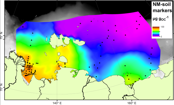
The paper studies a group of compounds called “bacteriohopanepolyols” (BHPs for short), which are found in the cell membranes of a range of microbes and are therefore one of the most common organic compounds around. They are found in modern and ancient sediments from all over the world. This study has concentrated on two groups of these. Group 1 is the soil marker compounds. These are only found in soils, and so have been used as tracers for soil material in rivers, lakes and offshore. Here is how they are spread across the East Siberian Artic Shelf:

BHPfig2a (Custom)
Soil marker compounds across the Arctic Shelf

Note how the soil marker concentrations are highest (orange colours) near to the rivers and coastlines. By measuring the concentration next to the river mouths, and in the sediments being washed away by coastal erosion, we show that it is not just rivers that are delivering the soil markers to the Arctic Ocean.

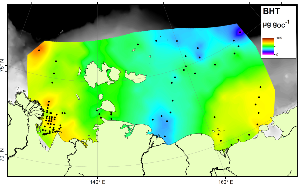
There is no single compound that is a true tracer for carbon produced in the ocean itself, but the compound bacteriohopanetetrol (BHT) is most abundant in marine settings despite being found in soils as well. Therefore if your sample is rich in BHT, and poor in soil markers, it is likely dominated by carbon from the ocean. Here’s a map of BHT across the East Siberian Arctic Shelf:

BHPfig2b (Custom)
BHT, a marine marker, is present across the Arctic Shelf

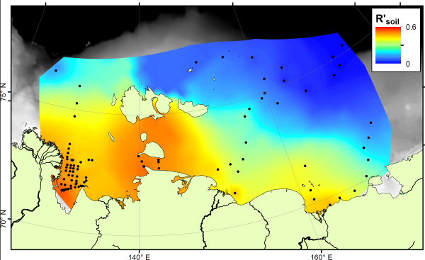
The BHT results show a fairly constant amount across the ocean floor. If we compare the soil marker concentrations to the BHT concentrations, we can see which areas are rich in soil carbon (more soil markers than BHT) and which are rich in marine carbon (more BHT than soil markers). This comparison is called the R’soil index, and is shown below:

R'soil index on the Arctic Shelf
R’soil index on the Arctic Shelf

The R’soil index shows that all along the East Siberian Arctic coastline, offshore sediments are dominated by carbon from the land. As you go further offshore, especially in eastern parts nearer to the Pacific Ocean, marine carbon is more important. This result shows a similar pattern to that seen using stable carbon isotopes, but is different to the pattern shown by the BIT index. Therefore these two indices, both based on microbial biomarkers, are tracing different parts of the carbon cycle.

Preservation of terrestrial organic carbon in marine sediments offshore Taiwan

This paper was published in the open access journal Earth Surface Dynamics, and is available through the journal website and the MMU e-space repository.

The paper is a combined effort from a large team of researchers interested in the way that organic carbon is exported from small tropical islands. These islands are very biologically productive, the forest grows quickly in the warm, wet climate. They are also responsible for delivering large amounts of sediment to the ocean. Rocks are weakened by earthquakes and then eroded by the frequent tropical storms that hit the islands. This washes sediment and carbon out to sea via two mechanisms. High sediment concentrations lead to ‘hyperpycnal’ plumes of material flowing along the ocean floor, lower sediment concentrations cause ‘hypopycnal’ flows that stay at the ocean surface. Both systems can spread sediments and carbon a long way offshore.

Marine sediment cores look very similar to the sediment coming out of the rivers

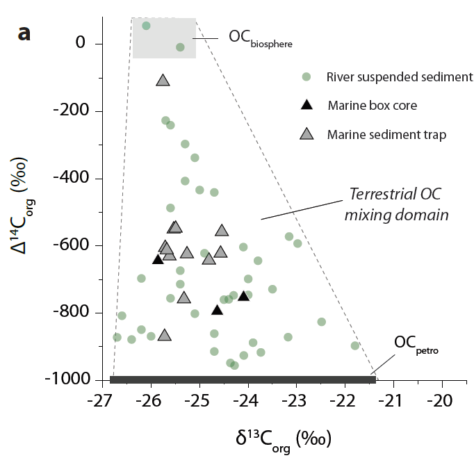
It had long been thought that hyperpycnal delivery of sediment, which usually only occurs in the most extreme weather conditions when floods deliver vast amounts of sediment to the ocean in a short period of time, were efficient methods of organic carbon preservation. Our data confirmed this hypothesis, showing that little terrestrial organic carbon was lost during transport, and little marine carbon added to the mixture.

However, the dataset also investigated how efficient hypopycnal delivery can be. Sediment and carbon are delivered throughout the year, in smaller floods and less extreme storms, and it had been suspected that this mechanism exposed the carbon to oxidising conditions where it could be degraded and released as CO2. We showed that in Taiwan, where hypopycnal conditions exist but are still receiving and accumulating a large amount of sediment, the burial efficiency of carbon in hypopycnal conditions is still very high. Marine carbon is mixed into the sediments, but at least 70% of the terrestrial carbon survives.

This means that small tropical islands are even better at exporting and burying carbon than was previously thought, and therefore better at sequestering atmospheric CO2. We estimated that more than 8 Teragrams (million tonnes) of carbon could be buried each year throughout Oceania.